Flash Flood Washes Out Himalayan Town: Causes, Impact, and Rescue Efforts in Dharali
A sudden cloudburst ripped through Dharali village, unleashing a devastating flash flood that claimed four lives and left dozens missing, sweeping away homes, roads, and vital bridges in its furious wake. This isn’t just a story of a natural disaster; it’s a critical examination of the forces at play. In this article, we’ll uncover the **causes** behind this tragedy, explore its **immediate consequences**, detail the heroic **rescue operations**, assess the **long-term risks**, delve into crucial **mitigation strategies**, and project **future climate impacts**. By mapping these interconnected themes—from natural triggers and human vulnerabilities to relief efforts and resilience measures—we aim to provide a comprehensive guide for policymakers, communities, and relief agencies, helping us all understand how to better protect lives and livelihoods in the face of nature’s raw power.
What Caused the Flash Flood in Dharali, Uttarakhand?
Imagine a wall of water, unleashed in moments, tearing through a peaceful village. That’s a flash flood – a rapid, destructive surge of water triggered by intense rainfall or a cloudburst in steep terrain, leaving communities little time to react. In Dharali, an extreme cloudburst on August 5, 2025, dumped over 120 mm of rain in under two hours. This overwhelming deluge, combined with the region’s fragile slopes, created the catastrophic wall of water. To truly grasp this event, we must look beyond the immediate downpour and examine the meteorological triggers, the underlying geology, the accelerating climate-driven trends, and the often-overlooked role of human development.
How Do Cloudbursts Trigger Flash Floods in the Himalayas?
Cloudbursts are not just heavy rain; they are sudden, localized deluges – bursts of rain exceeding 100 mm per hour – that can instantly overwhelm mountain catchments, sending torrents roaring downstream. It’s a perfect storm of atmospheric conditions:
- **Orographic Lift:** Humid monsoon winds are forced upward against the towering Himalayan slopes.
- **Rapid Condensation:** This rapid ascent concentrates moisture, forming intense rain cells.
- **Excess Runoff:** The sheer volume of water races downslope through narrow valleys, transforming into destructive flash floods.
These precise factors converged over Dharali, where steep channels acted like funnels, directing the water’s destructive energy straight into the village streets. This natural vulnerability sets the stage for our next crucial question: how did geology play a role?
Cloudbursts and Flash Flood Triggers
Cloudbursts, characterized by intense rainfall exceeding 100 mm per hour, are a primary trigger for flash floods in mountainous regions. These events, driven by orographic lift and rapid condensation, can overwhelm drainage systems, leading to devastating floods. The Himalayas’ steep terrain and narrow valleys exacerbate the impact of these events, funneling water into settlements.
This research supports the article’s explanation of how cloudbursts and geological factors contribute to flash floods in the Himalayas.
What Geological and Environmental Factors Worsened the Flood?
The Himalayas are breathtaking, but their geology holds a hidden vulnerability. The region’s steep relief and young, fractured rock beds naturally accelerate runoff and debris flow. Add to this the impact of human activity: deforested slopes, stripped of their vital root networks, can no longer absorb rain effectively, while loose sediments easily transform into destructive mudflows.
Impact of Deforestation on Landslides and Floods
Deforestation significantly increases the risk of landslides and floods by reducing soil stability and increasing runoff. Tree roots help to bind the soil and absorb rainfall, while the removal of trees leads to increased erosion and sediment yield. This can lead to increased debris concentration in floodwaters.
This research supports the article’s discussion of how deforestation and other human activities exacerbate the impact of flash floods.
Table: Geological and Environmental Factors
These factors, when combined with the cloudburst, didn’t just contribute to the flood; they magnified its depth and velocity, setting the stage for how climate trends are amplifying such events.
How Does Climate Change Influence Flash Flood Frequency in the Region?
Climate change isn’t a distant threat; it’s a present reality reshaping the Himalayas. Rising temperatures are increasing atmospheric moisture and making monsoon patterns more volatile, fueling more frequent and extreme cloudbursts. Beyond the rain, glacier retreat is forming unstable lakes that can burst, releasing sudden, devastating Glacial Lake Outburst Floods (GLOFs). Higher evaporation rates mean rainfall, when it comes, is heavier and shorter, dramatically raising flash flood risk across Uttarakhand and beyond. This escalating climatic context heightens the urgency of evaluating how human development impacts these already fragile systems.
Climate Change and Extreme Precipitation
Climate change is increasing the frequency and intensity of extreme precipitation events, including cloudbursts, in the Himalayas. Rising temperatures enhance atmospheric moisture, leading to more volatile monsoon patterns and an increased risk of flash floods. Glacier retreat and the formation of unstable glacial lakes further amplify these risks.
This citation provides scientific backing for the article’s claims about the influence of climate change on flash flood frequency and severity in the Himalayan region.
What Role Did Unplanned Development Play in the Disaster?
While nature sets the stage, human choices often amplify the tragedy. In Dharali, unregulated construction of roads and hotels directly on riverbanks narrowed floodplains and blocked natural drainage. Concrete embankments, built with good intentions, inadvertently prevented water from dispersing into side channels, instead funneling destructive currents straight into the heart of the village. Upstream, illegal logging reduced the vital vegetative buffers that normally slow runoff. These human alterations didn’t just contribute; they exacerbated the water volume and debris concentration, underscoring the critical need to address the immediate consequences of such a disaster.
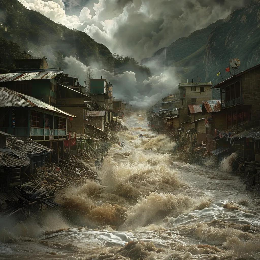
What Were the Immediate Effects of the Dharali Flash Flood?
The speed of a flash flood is terrifying. Within minutes, homes were inundated, vital roads washed out, and communication lines severed. Residents faced life-threatening currents and debris flows that left four confirmed dead and many unaccounted for. The flood struck during peak tourist season, compounding the economic losses for local families and businesses already struggling to make ends meet. This wasn’t just a natural event; it was a sudden, brutal disruption of lives and livelihoods.
How Many People Were Killed or Missing Due to the Flood?
The human toll is always the most heartbreaking. Four residents tragically lost their lives when torrents swept through Dharali’s lower wards. But the uncertainty lingered: more than 50 locals and visitors were reported missing as search teams tirelessly scoured debris-choked channels. Families grappled with agonizing uncertainty amid chaotic rescue efforts, highlighting the profound human cost of rapid natural disasters and prompting a large-scale, urgent relief mobilization.
What Damage Did the Flood Cause to Homes, Roads, and Infrastructure?
The scale of destruction was immense. Aerial surveys revealed over 200 homes destroyed or severely damaged, key roads rendered impassable, and two bridges completely collapsed – severing vital connections. Electrical poles snapped under the water’s relentless pressure, plunging the village into darkness. Hotels and guesthouses along the riverbank lost their ground floors, displacing dozens of tourists and shattering local economies.
Key infrastructure losses included:
- Homes: A staggering 60% of dwellings in low-lying sectors were ruined.
- Roads: 12 km of local roads simply vanished.
- Bridges: 2 crucial vehicular bridges collapsed.
- Power lines: 30 km of lines were downed, cutting off essential services.
These losses paint a stark picture of the destruction, leading us to consider the broader socio-economic consequences that ripple through a community long after the waters recede.
How Did the Flood Affect Local Communities and Tourism?
The impact extended far beyond physical damage. Local farmers, the backbone of the community, lost their irrigation channels as flood-looted silt clogged canals, jeopardizing entire crop cycles. Tourist arrivals plummeted by 80% after widespread media coverage, depriving small guesthouses and local businesses of vital revenue. School closures affected 300 students, as daily life shifted to temporary relief camps. The very fabric of community livelihoods was upended, demonstrating the urgent need for resilient planning that protects not just structures, but lives and futures.
What Environmental Damage and Debris Flow Resulted from the Flood?
The flood wasn’t just water; it was a destructive force carrying boulders, uprooted trees, and construction waste into the Mandakini tributary, smothering delicate aquatic habitats. Over 5 km of riverbank vegetation was stripped bare, and massive sediment deposits drastically altered the river’s morphology. Wildlife corridors were disrupted, revealing cascading ecological effects that demand integrated restoration measures – a reminder that nature’s fury leaves a lasting mark on the environment itself.
How Were Rescue and Relief Operations Conducted After the Flash Flood?
In the immediate aftermath of such chaos, every second counts. Emergency response began within hours, mobilizing military helicopters, specialized disaster teams, and local volunteers who bravely stepped forward. Coordination between various agencies was paramount, focusing on locating missing persons, restoring critical services, and providing essential supplies, all while continuously assessing ongoing risks. It was a race against time, driven by a singular purpose: saving lives.
What Role Did the Indian Army and SDRF Play in Rescue Efforts?
When disaster strikes, heroes emerge. The Indian Army swiftly deployed two Mi-17 helicopters for aerial reconnaissance and critical casualty evacuation, conducting over 15 sorties in the first 24 hours alone. State Disaster Response Force (SDRF) teams, equipped with inflatable boats and life-jackets, bravely navigated submerged structures to extract survivors. These joint operations saved 80 people, a testament to military precision and the specialized training essential for mountain rescues.
How Did Local and State Authorities Respond to the Disaster?
Leadership is crucial in a crisis. Uttarakhand’s Chief Minister immediately announced a red alert and released emergency funds for relief efforts. Local administration rapidly established three relief camps, distributing vital food kits to 500 families and organizing essential medical camps. The India Meteorological Department issued updated flood warnings for neighboring basins, guiding ongoing vigilance and proactive measures. It was a coordinated effort to bring order to chaos and provide immediate solace.
What Eyewitness Accounts and Survivor Stories Highlight the Event?
Behind every statistic is a human story of survival and resilience. One shopkeeper vividly described watching a wall of water engulf his store “in less than a minute,” scrambling to higher ground with his family, their lives forever changed. A tourist recounted being rescued after clinging to a fallen tree for eight hours, until brave SDRF divers finally arrived. These personal narratives don’t just illustrate human resilience; they underscore the unpredictable, terrifying nature of flash floods, leading us to consider the looming challenges that persist long after the initial shock.
What Are the Long-Term Risks and Challenges Following Himalayan Flash Floods?
The immediate crisis may pass, but the shadow of recurrent flash floods lingers, threatening recovery efforts, sustaining economic hardship, and eroding community trust in vital infrastructure. Without strategic, forward-thinking interventions, each event compounds displacement, heightens vulnerability, and tragically stalls regional development. The challenge isn’t just to recover, but to build a future that can withstand the inevitable.
How Does Infrastructure Vulnerability Increase Flood Damage?
Our infrastructure, meant to protect us, can become a weakness. Aging bridges and narrow mountain roads, often built decades ago, amplify collapse risks under the immense pressure of high water. Unreinforced masonry housing, common in the region, offers little defense against debris impact, while hydropower dams lacking adequate spillway capacity face the terrifying threat of overtopping. These vulnerabilities aren’t just design flaws; they are direct threats to human safety and economic stability.
Table: Infrastructure Vulnerabilities
Improving structural resilience isn’t just an engineering task; it’s essential to reduce future losses and protect communities, leading us directly into the profound socio-economic impacts that follow.
What Are the Socio-Economic Impacts on Displaced Communities?
When a community is displaced, the ripple effects are devastating. Displaced families often lose not just their homes, but all their assets, facing lodging costs in relief shelters and relying on external aid for weeks, sometimes months. For agrarian communities, incomes can plummet by up to 60% post-flood due to damaged fields and irrigation systems. Beyond the financial strain, psychological stress increases dramatically, leading to long-term health and social support needs. These immense pressures underscore why regional planning must integrate robust economic safety nets and compassionate support systems.
How Do Repeated Floods Affect Regional Development and Safety?
The cycle of repeated floods creates a pervasive sense of insecurity. Frequent disruptions deter vital investment in tourism and infrastructure, stifling economic growth. Schools and clinics face repeated closures, limiting human capital development and access to essential services. Insurance premiums skyrocket, and government budgets are strained by recurring relief allocations, diverting funds from long-term development. Recognizing these cascading effects highlights the critical importance of robust, proactive mitigation strategies – a shift from reaction to prevention.
How Can Flash Flood Risks Be Managed and Mitigated in the Himalayas?
Breaking the cycle of damage requires a multi-faceted approach. Effective risk management isn’t just about reacting; it combines cutting-edge forecasting, deep community engagement, sustainable land use practices, and sound policies to build true resilience. It’s about empowering communities to stand strong against nature’s fury.
What Early Warning Systems Are in Place for Flash Floods?
Minutes can mean the difference between life and death. Authorities now rely on sophisticated India Meteorological Department forecasts, real-time rain gauges, and river-level sensors linked to mobile alerts. Automated SMS warnings now reach 1,200 villages, while local radio and sirens supplement digital channels, ensuring that critical information reaches those most at risk. These systems buy precious minutes for evacuation, paving the way for the next crucial step: community preparedness.
How Can Community Preparedness Improve Disaster Resilience?
The most powerful defense often lies within the community itself. Communities can organize mock drills, establish local relief committees, and meticulously map safe evacuation routes. Training villagers in essential first-aid and water rescue techniques fosters invaluable self-reliance. Village-level storage of emergency supplies and the construction of elevated community halls reduce dependence on distant relief centers, reinforcing local capacity and ensuring that communities are ready *before* events strike.
What Sustainable Development Practices Reduce Flood Impact?
Working *with* nature, not against it, is key. Terrace farming and widespread reforestation efforts stabilize slopes, dramatically reducing runoff velocity. Banning construction in vulnerable floodplains preserves natural water storage areas. Incorporating permeable road designs and bio-engineering riverbanks with native plants helps diffuse flood energy naturally. These practices aren’t just environmentally friendly; they integrate environmental stewardship directly with disaster risk reduction, creating a more harmonious and resilient landscape.
What Role Do Policy and Governance Play in Flood Control?
Ultimately, effective flood control requires strong leadership and clear frameworks. Clear land-use regulations, strict enforcement of buffer zones along rivers, and the establishment of multi-stakeholder governance bodies ensure coherent, coordinated action. Policies must incentivize climate-adaptive infrastructure, mandate thorough environmental impact assessments for all new projects, and crucially, allocate funds for preventive measures rather than solely reactive relief. This creates a resilient legal and administrative framework that protects communities for generations.
How Is Climate Change Shaping Future Flash Flood Scenarios in the Himalayas?
The future of the Himalayas is inextricably linked to climate change. Rising temperatures and rapidly retreating glaciers will fundamentally alter the region’s hydrology, amplify extreme rainfall events, and dramatically increase the threat of Glacial Lake Outburst Floods (GLOFs). These shifts demand urgent, adaptive strategies for long-term safety and survival in a changing world.
What Are the Projected Impacts of Climate Change on Himalayan Hydrology?
The numbers are stark: climate models forecast a 20–30% increase in extreme precipitation events by 2050. This will accelerate glacier melt and elevate river baselines, fundamentally changing water flow. Peak flows may shift from the monsoon season to spring as snowpack diminishes earlier. These profound hydrological shifts will intensify flash flood patterns and place immense stress on water resource management, demanding innovative solutions.
How Are Glacial Lake Outburst Floods (GLOFs) Increasing Flood Risks?
As glaciers melt, they leave behind moraine-dammed lakes – vast bodies of water held back by unstable natural dams. These lakes are vulnerable to sudden breaches, and when they burst, GLOFs can release millions of cubic meters of water in minutes, generating waves that obliterate downstream villages with terrifying speed. Monitoring and controlled drainage of these high-risk lakes are not just important; they are critical to preventing catastrophic outbursts and saving countless lives.
What Adaptation Strategies Are Recommended for Long-Term Safety?
Building a safer future requires a blend of engineering and nature-based solutions. Engineering measures like robust spillways, dam reinforcements, and debris-flow barriers can significantly reduce flood energy. But we must also embrace nature: restoring wetlands and alpine meadows enhances natural water absorption. Beyond infrastructure, community relocation from high-risk corridors and the diversification of livelihoods into non-flood sectors offer long-term resilience, ensuring communities can thrive even in a changing climate.
How Does International Cooperation Support Himalayan Flood Research?
The Himalayas transcend borders, and so must our solutions. Organizations such as ICIMOD and WMO facilitate crucial trans-boundary data sharing on glacial dynamics and rainfall patterns. Joint capacity building initiatives, advanced satellite monitoring programs, and standardized risk assessment frameworks strengthen regional preparedness and inform evidence-based policy across all Himalayan nations. This global collaboration is vital for understanding and mitigating a shared threat.
What Are the Most Frequently Asked Questions About Himalayan Flash Floods?
Below are concise, direct answers to common queries on Himalayan flash floods, optimized for quick reference and clear understanding.
What Causes Flash Floods in the Himalayan Region?
Flash floods in the Himalayas are primarily caused by intense cloudbursts, extreme monsoon rainfall, the region’s fragile geology, and human activities like deforestation and unplanned construction in steep terrain.
Which Towns Are Most Vulnerable to Flash Floods in Uttarakhand?
Low-lying towns situated along narrow valleys—such as Dharali, Joshimath, and Raini—face the highest risk due to their location within steep catchments and limited evacuation routes.
How Many Casualties Resulted from Recent Himalayan Floods?
In August 2023, Himalayan floods tragically killed at least 72 people and displaced thousands. The Dharali event alone claimed four lives and left over 50 individuals missing.
Why Are Cloudbursts Common in the Himalayas?
Cloudbursts are common due to the orographic uplift of moist monsoon winds against the steep mountain faces, which concentrates rain into localized, high-intensity downpours that trigger sudden floods.
Is Climate Change Increasing Flash Flood Frequency in the Himalayas?
Yes, absolutely. Warming temperatures enhance atmospheric moisture and rainfall intensity, accelerate glacier melt, and consequently elevate both the frequency and severity of flash floods in the region.
Four years of consecutive cloudburst events underscore a critical truth: we need integrated mitigation, informed by precise scientific forecasting, sustainable land use, and resilient infrastructure. By truly understanding the complex interplay of natural forces and human choices, stakeholders can dramatically reduce loss of life, safeguard precious livelihoods, and ultimately build a more flood-resilient Himalayan region for generations to come.